

THE NEW PARKS OF KINGSCLIFF
Sugar Mill Parklands

Images below: Sugar Mill Park South, Sugar Mill Park North and Sugar Mill Rainforest Track


Sugar Mill Park is situated east of Tweed Coast Road between Cudgen Village and the new Tweed Valley Hospital. The concept underlying the parklands is a series of trails for walkers and cyclists, exercise stations, central grass areas, pocket parks, picnic and seating opportunities.
The parklands will retain existing trees and the adjacent bushland will be protected as Ecological Conservation lands.
The idea behind the name ‘Sugar Mill Park’ is to acknowledge the historical importance of the Cudgen Sugar Mill Archaeological site on the adjacent high land, which is a point of significance weaving in the earlier history of Kingscliff and can provide a café and car parking.
Quigan Park
CREATING A BETTER, GREENER KINGSCLIFF
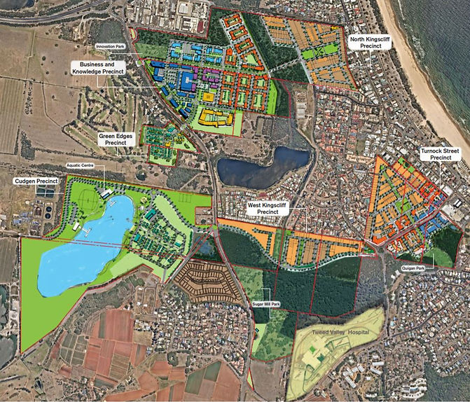
Gales Masterplan for Kingscliff with Sugar Mill Regional Parklands circled in red and Quigan Park circled in yellow
Where natural beauty and modern life converge
The parklands for Kingscliff proposed by Gales, currently in Gales ownership, are central and convenient to existing and future residents,
and provide a wonderful rainforest and shaded experience quite different to the existing open beachside more linear parks in Kingscliff.
The parklands are an outstanding opportunity to benefit current and future residents and staff, patients and visitors of the Tweed Valley Hospital.
We invite you to scroll this site and take the survey at the end.
We welcome your comments.

Quigan Park is located between Quigan Street and the proposed town centre extension along Turnock Street. This park will enhance the liveability and amenity for the new residential and mixed use development and for current residents in the area. This park, with shaded open space, a kickabout area and adjacent dense rainforest, will provide a quiet retreat from the bustling main street and coastal foreshore.
This park, which is currently slashed grassland, will not require the removal of any vegetation and will create a fire break from the otherwise continuous vegetation to Tweed Coast Road thereby reducing the fire hazzard to the Kingscliff CBD and residences.
Click through photos of parklands as they are today

Sugar Mill South

Sugar Mill South

Rainforest Track

Rainforest Track

Rainforest Track

Rainforest Track

Sugar Mill North

Sugar Mill North

Quigan Park
Active Open Green Spaces
Shaded Rainforest Nature Walks
Family Friendly Safe Parks


Maps below show limited parks and extensive bushland in the area

GALES VISION
ACTIVE PARKLAND
and
BUSHLAND
Nature for people to use and enjoy
Parks such as Gales are rare to non-existent in the area. Gales envisions wonderful parklands, with adjoining bushland conservation areas.

COUNCIL'S VISION
BUSHLAND
but no
ACTIVE PARKLANDS
Access restricted to paths, no open vistas
Council's Kingscliff Locality Plan envisions more bushland, which is already extensive along
the Tweed Coast.

In this Council map the green areas indicate existing parks and sportsfields in Kingscliff - mainly along the coastal strip.
Council wants the areas circled in orange to be more bushland with restricted access, rather than active parks for Kingscliff residents to enjoy.
